
The Yellowbelly Track launched in February 2021. Since then I have found more river tracks that join up. More importantly parts of the Yellowbelly Track flooded in 2022 and again in 2023. Even parts of the Yellowbelly Track – roads route flooded. I had planned for the roads route to be more immune from bad weather.
Although it was clear the Yellowbelly Track needed an update, this took a while to do. I didn’t want to put out an update until I was confident I understood the cause of increased floods. I also wanted to tell riders how they could manage flood risk.
The Earth Rivers and Ironbark (ERI) route launched in December 2025. Part of the ERI covers a similar route to the Yellowbelly Track. Specifically for riders travelling between Echuca and Tallarook. The information and routes in the ERI, provide an opportunity to refresh and update the Yellowbelly Track. There is now Yellowbelly Track v2.
Yellowbelly Track v2 – route comparison
The main differences between Yellowbelly Track v2 and Yellowbelly Track v1 are:
- Yellowbelly Track v2 includes more earth and gravel roads, and less sealed roads.
- Yellowbelly Track v2 includes more tracks riding beside rivers.
- Yellowbelly Track v2 includes rougher sections of track with more tree fall.
- Yellowbelly Track v2 – wet alternative route is more robust. It excludes all the earth sections and is further away from areas that could flood. It is also longer and includes more sealed roads and busy sealed roads than the previous roads route.
- Yellowbelly Track v2 avoids Kirwans Bridge at Nagambie which is still closed.
- Yellowbelly Track v2 includes the new lakeside bike path on south bank of Lake Nagambie. This is longer and more scenic than Kirwans Bridge.
Overall Yellowbelly Track v2 is 15km longer and more scenic than Yellowbelly Track v1. It is also slightly harder and slower.
The table below shows the surface and distance comparison between Yellowbelly Track v2 and Yellowbelly Track v1.
| Surfaces | Yellowbelly Track v2 (km and %) | Yellowbelly Track v1 (km and %) |
|---|---|---|
| Earth / Silt / Clay | 75 (34%) | 64 (31%) |
| Gravel Path | 9 (4%) | 11 (5%) |
| Sealed or Solid Path | 8 (4%) | 0 (0%) |
| Gravel Road | 57 (26%) | 52 (25%) |
| Sealed Road – Quiet | 64 (29%) | 73 (35%) |
| Sealed Road – Busy | 7 (3%) | 6 (3%) |
| Total | 221 (100%) | 206 (100%) |
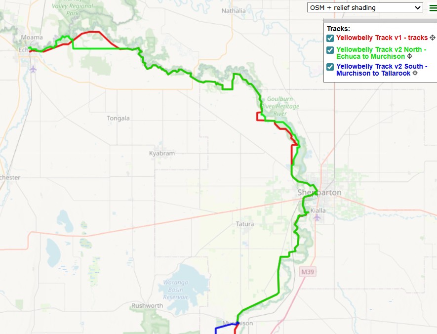
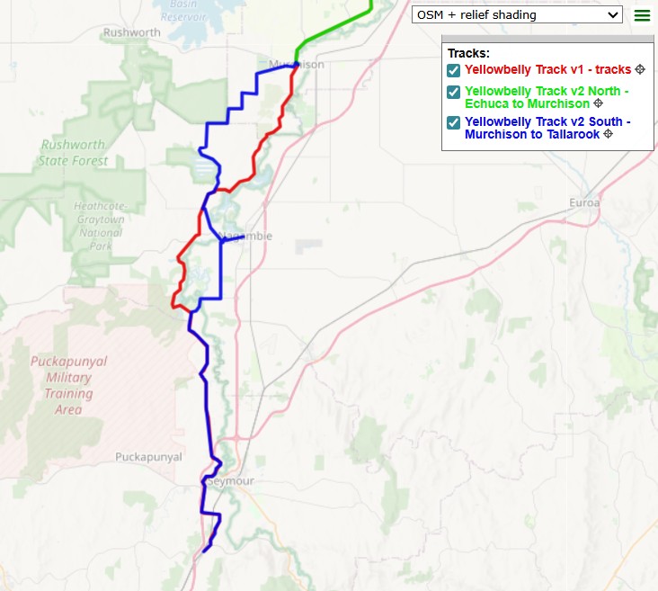
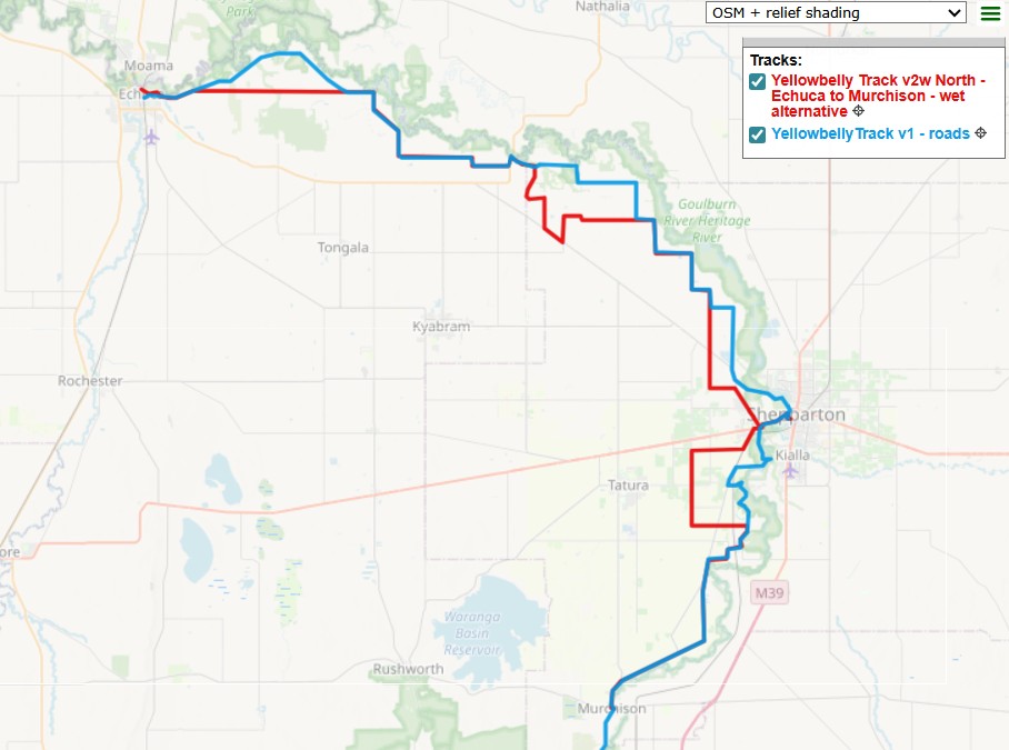
The maps below show the difference in the routes.
- The left map shows the north end of Yellowbelly Track.
- The Green line is Yellowbelly Track v2, the Red line is Yellowbelly Track v1 – track route.
- The middle map shows the south end of Yellowbelly Track.
- The Blue line is Yellowbelly Track v2, the Red line is Yellowbelly Track v1 – tracks route.
- The right map shows the north end of Yellowbelly Track.
- The Red line is Yellowbelly Track v2 – wet alternative. The Blue line is Yellowbelly Track v1 – roads route.
.
Ride through Video
If you want to see what Yellowbelly Track v2 looks like, watch the first part of the video below. This video provides a ride though of the ERI. However, the images in the first 5:42 mins (189 km) of the video are identical to Yellowbelly Track v2. The remaining 32 km of Yellowbelly Track v2, from Mitchellton to Tallarook, are the same as Yellowbelly Track v1. The video narration is not relevant to Yellowbelly Track v2 though.
.
GPX Files
Just as with Yellowbelly Track v1, there is no road signage or markers for Yellowbelly Track v2. To avoid getting lost, it is essential riders navigate using GPX files – with local files on your device. If you need to improve your navigation and technical skills see this page – Navigating with GPX files.
The route GPX files are available for free on RWGPS in a collection (links are below). The files are marked private, but are available to users who have been given the link.
To access the files, all users will have to have or create a RWGPS account (there is a free option).
The Yellowbelly Track v2 GPX is split into 2 files. A north and south section. Only the north section has a wet alternative route. The south section does not need a wet alternative route.
The RWGPS Collection includes the GPX files for both Yellowbelly Track v2 and Yellowbelly Track v1.
.
AI Planning Tool
You can also use the Earth Rivers and Ironbark Planner to plan your ride of Yellowbelly Track v2. Specify the locations you plan to ride between. The Planner will give the same response whether you are on the ERI or Yellowbelly Track.
Go to the Earth Rivers and Ironbark Planner page for instructions and the link to the AI Planning tool.
.
Comment and Contact
Thanks for reading and your interest!
The Nix-Tracks.com website hosts ride reports about the routes. If you ride the new Yellowbelly Track v2, please consider writing a ride report. Ride reports with tips and pics help other users with their plans.
The fastest way to contact me and get a response is to make Comments here. I get a personal message email whenever anyone posts a Comment here and try to respond quickly. Access to the comment section is set so anyone can use it. You don’t have to login or give any personal details. Just type your thoughts.
You could send me an email using this email address (nixtrader AT yahoo DOT com DOT au). However, this email address is rarely used and I don’t monitor it frequently.
.

Leave a comment