This interactive map of the GABCY Network makes it much easier for riders to plan their adventures.
You can access the map via this link – GABCY Network Interactive Map – which should open in another tab.
The link above is for the map only. Keep this tab open as you will need to refer back to this page for the Legend and Instructions on how to use the map.
The map has multiple levels of information:
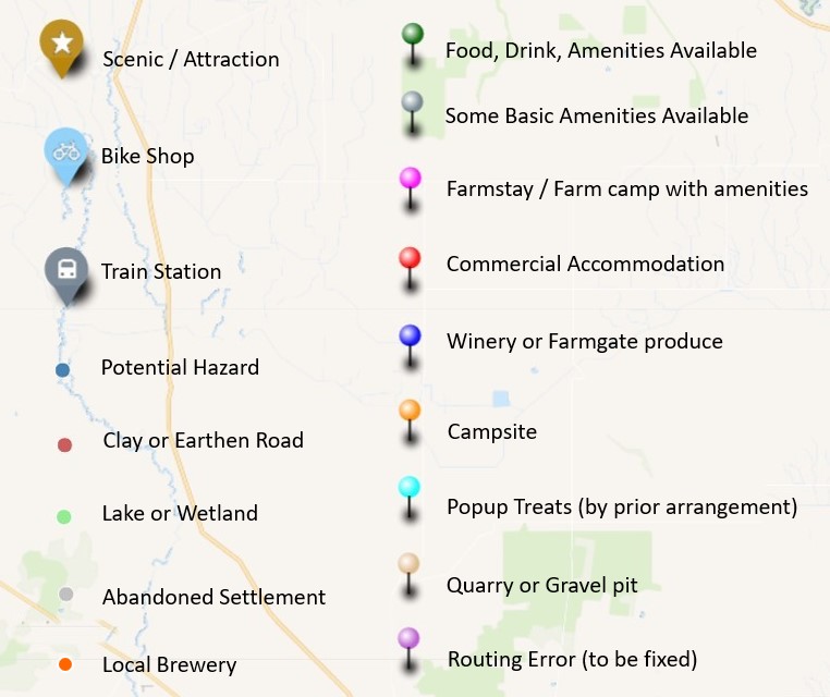
- As shown in the Legend above there are many different marker types on the map.
- Zoom in to see how routes join up at various points, and to look at the street maps for towns.
- Hover over routes or pins to see information pop up.
- Click on routes or pins to see more detailed information.
- Click on web links in the pop ups to see even more detail.

Instructions – how to use Buttons on left of the map
- Zoom controls
- + to zoom in closer
- – to zoom out
- Search: this finds roads and streets from the background map so it isn’t very helpful.
- Full screen toggle button.
- Measure distance button.
- Click the button, then click map to start measuring.
- Click new points to add more sections to distance tally. Click last point to end distance count.
- Click Measure button again to remove measuring.
- Change background map button. Various background maps have different amounts of information – e.g. roads v terrain.
- Manage layers button (a.k.a. ‘pancake stack’ button).
- This one is more complicated – see below.
Managing Layers
All the information on the map is in different layers. For example, all the campsite markers, the orange pins, are in the same layer, and every route is in a separate layer.
Each layer can be turned on and off independently, so the user only sees the information they are interested in. For example, you can choose to hide either the campsites (orange pins) or the commercial accommodation locations (red pins), depending on your overnighting plans.

To manage layers click on the bottom button on the left side of the map (the round pancake stack button). The dialogue box shown on the right will open, listing the layers. You can scroll through them all.
There are two icons on the left of each of the layer names.
- The eye icon – click on this to change whether you see or hide that layer.
- The find icon – click on this and the map will centre and zoom in on the information in that layer.
If you click on the dark bar “Browse Data” along the bottom of the box, a more detailed view opens on the right-hand side. You can use that dialogue box to select and zoom in to any of the individual routes or markers.
When multiple routes overlap in a location you can turn some route layers off so only the route(s) you are interested in is visible.
.
All the changes you make to the map are temporary. If you turn lots of markers off, or change the background map, the easiest way to revert to the starting map is to reload / refresh the map.
.
The map isn’t finished yet, there is more information to add. But it is usable in this form so I’ve published it now. Please use comments below to make suggestions about what else you would like to see on the map, or if you would like more instructions on how to use the map.
.

Leave a comment