Writing reports about my activities is something I am not very good at. I have many half written posts that I never finish. I usually get distracted by my next epic scheme before I finish writing about the last one.
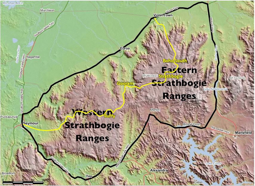
However, I will write up the first Strathbogie Slider ride to assist riders for the following week. I will not repeat basic information about the ride, so for the details about the route see the Strathbogie Slider ride page.
The inaugural Strathbogie Sliders were a small select group. All were excited by the challenge and the adventure of tackling a new route, and all completed the ride without mishap, not even a puncture.
Pre-ride
Despite all the planning it is always possible for unexpected things to happen the first time you try something. Three of the riders met up at Violet Town to catch the morning train. We were all on the old Violet Town station platform 10 mins ahead of the train time. However, when the train came it stopped at a different more modern platform on the east side a little way down the track. So we had to scurry with our bikes down to where the train was, with railway staff encouraging us to move faster as we were holding up the train.
The old station building is in the upper right corner of the image below, under the train icon. The level crossing on the main road is in the upper right corner as well. The platform we needed to be on for southbound trains is the long pale diagonal line pointing towards the lower left corner.

We loaded our bikes into the luggage van. The van had places for bikes, but other luggage was spread out in most of the spots. The train started off while we found spaces to secure our bikes and sorted our tickets with the conductor.
The cafe in the cafe car was closed. Apparently it closes at Violet Town so the barrista can clean up and get off at Euroa, the next stop. Another barrista gets on and reopens the cafe from Seymour for the trip to Melbourne. But unfortunately for us no cafe bar on our trip from Violet Town to Seymour. I’d also found out that the retro cafe in the old waiting room on Seymour Station was closed weekends. So that meant we would have to go to a local cafe in Seymour before the start.
The train was a few minutes late and we unloaded our bikes. The fact we loaded and unloaded our own bikes is a good thing I think. I had a brief but helpful discussion with conductors about better planning for bikes next week, then we went to the coffee shop.
By the time we had coffee, got all the riders together, and rode back around to the east carpark to start it was 9:50am. As this ride took much longer than expected, it is important to start on time next week.
The Ride
The weather forecast was good – sunny day and temperature in mid 20s. However, after a week of southerlies, the wind had moved to a less favourable quarter. It was forecast to move between NE and NW, starting at 10km/hr, becoming stronger later in the day.
We started at 9:50am into a slight headwind. Highlands Road had a bit of traffic close to Seymour, but this thinned out as we moved further away from the town.

Time passed quickly as riders who didn’t know each other chatted. Soon we turned onto Hughes Creek Road and then surprisingly quickly we heard the first crunch as our wheels rolled off asphalt onto gravel.

As expected the unsealed road surface was quite hard. The pebbles scattered around the surface were a bit bigger than I expected, however they were rounded and didn’t impede riding.
We made good progress to the creek crossing, with a brief stop at the Bankin memorial.
After the creek crossing the road deteriorated, although it was still rideable. Ponkeen Creek Road had more corrugation than I expected. There was plenty of sliding around when the corrugation was combined with loose gravel and a banked corner. Occasionally there was a hole in the road surface where part of a pipe culvert had collapsed underneath the road. We also encountered a breakaway group of cattle on this road when we rounded a corner. We completed this section without incident, but it was slower going. It was a good reminder to only proceed at a speed where we were able to stop safely before any hazard.
A right turn onto Tarcombe-Ruffy Road marks the beginning of the first major climb up to Ruffy – see profile below.

The climb happens in short sharp steps. There are some ruts in the road climbing out of the first valley. Many of the little ramps include short bites with double digit gradients.
Riders who look up from their stems will see striking rock formations along this climb.
 The climb ends with 600m of sealed road that is probably the steepest section.
After more than 20km of gravel and a steep climb we arrived at Ruffy Produce Store for the first feed break. A large table was set up for us under the big tree out the front (see photo below). I was very happy to see two plastic barrels of chilled water from a natural spring out the back of the cafe that the owner had put out for us. We all commented that it was unusual to pull up at a cafe stop and feel this welcomed.

I ordered a “big sausage roll with home-made relish and salad”. It was a huge sausage roll and was the butt of many jokes, even from people wandering passed our table. It isn’t often a cyclist can’t finish what is put in front of him on a ride. My companions went for the cottage pies with salad and were happy with the results. This is a very pleasant place to sit around and chat – we were here for over an hour and could have stayed longer if we weren’t on a mission.
Eventually we started rolling again – up Buntings Hill Road and into Sinclairs Lane. Sinclairs Lane is the most borderline section of this route as it is close to a track. However, consensus among my companions was that it was quite rideable and a bit of fun, and I should keep it in. It is a mixed bag with some short rocky sections and even a short stretch of sand.
Sinclairs Lane is an exception; for the most part, the surfaces of the gravel sectors on the plateau are better than they were on the climb up. In general the unsealed road surfaces get better the closer riders get to the end of the ride.
After a quick connecting link on asphalt, we turn left onto Killeens Hill Road. This road was to be our companion for some time. It has 3 distinct stages – the plateau, the descent and the valley. The plateau surface was pretty good – it had some longer straight sections, with scenic outlooks and then a series of tight bends following the ridge line and avoiding trees where the surface was a bit more rutted.

Controlled is the key word to describe our descent. Everyone kept their bikes on a tight rein and took a wide central upright line around the many corners where gravel was thicker on both sides of the road. I was happy my bike had in-line CX type brake levers here and gravel tyres, although riders with more conventional road bike setups also got down without incident. Later analysis shows we descended at a slightly slower average speed than the previous plateau section which I wouldn’t have expected pre-ride.
When we regrouped at the bottom it was apparent we had a timing issue. While everyone was very happy with the ride experience, it was taking much longer than expected. We were not yet half way and it was already 3pm. However, with the exception of Galls Gap climb, I expected that we should be able to do the remaining part faster and so make up some time.
We had a slight headwind as we headed north up the valley and the gravel eventually turned into a one lane ribbon of asphalt. The short 2km link on the major Euroa-Mansfield Road was uneventful – we didn’t see a vehicle.
This bought us to the foot of the biggest climb of the day … Galls Gap Rd. See strava profile below. The strava KOM for this segment is under 20 km/hr.

The first 2km averages about 6%. The fun starts at half-way with a 300m long step that averages about 15%. Then it levels off a bit before finishing with a last kilometre at over 12%. The strava KOM for the last kilometre is under 15km/hr.
I make no pretence at being a climber; I don’t mind admitting that I walked a lot of this. So I don’t have a graphic tale of my suffering to share. I can tell you the road has quite a pleasant outlook – it is surrounded by trees and follows a scenic but very deep creek gully up to the plateau. I think I was passed by 2 cars, so riders should expect some traffic on this road.
Resuming riding on the plateau, we became aware the wind had moved to NW and was cooler – so we had a cool breeze across our backs which was refreshing.
The lead group didn’t stop at Polly McQuinns weir, but we laggards did.

It is a pretty spot. It was great to sink my wrists into the cool flowing stream and soak my buff and wipe my face and head, before putting it back on. I recommend a brief cooling stop here even though it is only a few kilometres before Strathbogie.
Before long we were in Strathbogie town for the second and final feed stop. We still had about 35km to ride, and it was 6pm by the time we left. I was still optimistic we would get faster as we had done all the hard stuff. This didn’t prove to be the case.
We didn’t make any more stops and rode till the end. I think the long day of riding was starting to take its toll. Brookleigh Road was the slowest section of the whole route. The asphalt sections were undulating and I found it difficult to get into a rhythm and pick up the average speed.
The lead group of riders missed the last turnoff onto Upper Boho Road and so descended on Harrys Creek Road which was sealed.
The laggards which included me took the risk and decided to chase the thrills of the gravel descent in fading light. The 5km ride out to the ridge edge at golden hour was very pleasant.

The road surface for the descent was very good for an unsealed road, but we still kept our bikes under tight control as there were occasional lumps of white rock and corrugation to swerve around. Dropping off the ridge, through a forest, in fading light, on gravel for 8km with sections at -8% was a memorable experience. I could hear startled kangaroos bouncing through the trees at the road edge. But I dared not lift my eyes from the gravel ahead to see exactly where the roos were – I just hoped they stayed off the road. Fortunately, we reached the bottom of the descent and finished the gravel while there was still some light. While this was an exhilarating experience, I don’t think we should try to repeat it.
The majority of riders were not carrying adequate lights and both descent routes had many kangaroos at dusk. So a key issue for riders next week is to carry lights and to manage the time better to get off the ranges earlier. After riding the route it seems there are several slow sections, but no real opportunities to go fast and make up a lot of time (or not safely anyway). And this was without any stacks or mechanical issues. Even 1 puncture in our the group would have meant a much darker descent. For next week I will make up a time schedule to help riders realise when they are starting to fall behind the time needed to get off the range and into Violet Town while there is still good light.
However, the long ride time was the only surprise. Everything else came out well. All riders stayed upright and there were no mechanical problems. The gravel roads were all rideable with care, and didn’t contain hidden sharp objects to rip tyres and cause lots of punctures. The weather was good, the scenery spectacular and the stops very enjoyable. All riders enjoyed the experience very much and the different bike configurations all made it through. A special thanks to my fellow riders on the day – the inaugural Strathbogie Sliders. Your company made it a very special day.
Leave a Reply