Update 23/10/22: Ride Cancelled.
Unfortunately, I am cancelling this ride. For two reasons.
Firstly a dam has extended out over a track and the water looks too deep to ride across. The water is over an s-bend in the road so not sure where the road would even be under the water. We could detour around it but that would entail riding about 10 km on an unpleasant road. Because it is a dam, the forecast rain will flow into this blockage so it is not likely to clear before Saturday.
Secondly, most of the wildflowers have gone. It looks like the heavy rain stripped them. Some more flowers might pop up but it is unlikely before this weekend when more heavy rain is due.
——————– Original Post ——————–
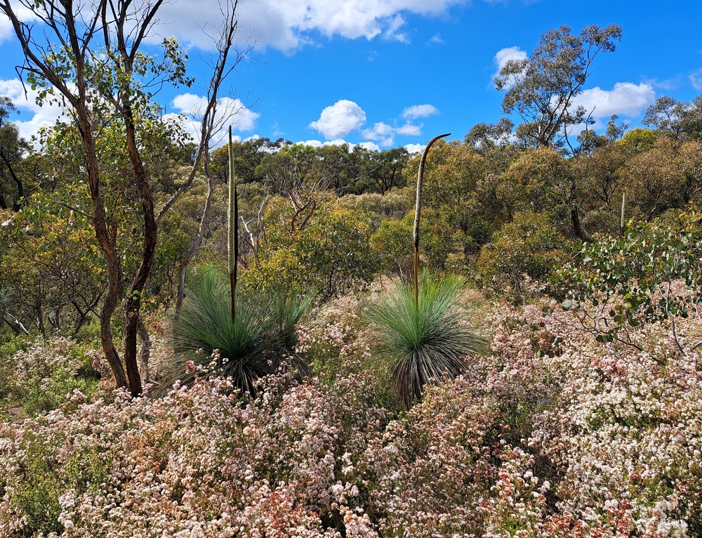
It’s a La Nina season with plenty of spring rain. This means it is a good season for native ground fungi, and a great season for the wildflowers that depend on fungi for part of their nutrition.
Spring wildflowers are plentiful in the Rushworth Ironbark forest and are often most abundant close to grass trees (Xanthorrhoea). Both plant types are more prevalent in areas of forest that have been less disturbed since European settlement.
The thin sandy topsoil and gravel tracks on the rolling hills of the Rushworth forest also drain well, so it is better riding there in a wet spring than on flat muddy river plains.
- Date and Time: Saturday 29th October. Start 9:30 am.
- Distance and Duration: Route is 65 km. It will take 4 to 5 hours, depending on your number of photo stops.
- Start and Finish location: High Street, Rushworth.
- Amenities and Accommodation: Rushworth has food, water and accommodation available. There is no drinking water along the route, so please carry enough for your needs plus extra for emergency situations.
- Terrain: There are no major climbs, but the route is rolling with continual short climbs and descents of around 3-5%. Total vertical metres is 514 m for the ride. See profile below.
- Roads and Ride Surfaces: Most of the route is smooth and clear – 94% gravel and natural surface road and 6% quiet sealed road. There are some ruts, potholes and rougher gravel sections, as well as puddles and shallow water across the roads, but you can ride around these, or ride through them slowly.
- Traffic: Vehicle traffic will be light everywhere. The busiest section will be the 2 km sealed road into and out of Rushworth at the start and finish.
- Best Bike: No need for suspension as most of the surfaces are fairly smooth. But riders will probably find the jarring and vibration from the gravel roads uncomfortable on tyres less than 30 mm wide. To be comfortable you should have tyres wider than 40 mm if possible.
- Navigation and Communication: Many of the forest tracks are not marked and winding. It is difficult to maintain a sense of direction in this forest. Some areas along the route will be outside mobile phone and internet coverage. To prepare for this ride I think it is essential to download the gpx file and put it onto a gpx tracker that will operate outside of mobile and internet coverage. Adventure riders should always carry personal locator beacons for emergency situations.
- GPX File: Will be provided when the route is finalised.
- Highlights: Rushworth historic township with good food options. Rarely seen native grass trees and many wildflowers in bloom. Very low car traffic. Good riding on red, scenic, smooth, natural surface and gravel tracks rolling and winding through the forest.
- Critters: The forest is home to many snakes, spiders, magpies, wallabies and other native animals. In spring many animals become more active in seeking mates and more aggressive in protecting their offspring and territories from threats. Many small stinging insects such as bees, wasps and mosquitoes are attracted to these wildflowers and are pollinators. Please do your own research and risk assessment, and wear or carry what you need for the ride.
- Cost and Support: It costs nothing. For that you get to ride completely self-supported, self-navigating and at your own risk. There will be no marshalls, no route markings and no physical or mechanical support people or vehicles. Please do your own research and risk assessment to determine if this is a suitable ride for you.
- Seasonal Ride Series: This route is part of the GABCY Seasonal Ride Series – a set of monthly rides that are in harmony with local weather patterns and natural environments. The aim is to showcase the most suitable and scenic time to ride in each location, as well as show the wide variety of rides available across the GABCY Network.
- Route also connects with: If you want to make a longer day-ride, or multiday-ride, this route has connections with Golden Black Track, Camel Cornella, Kirwans Rushy Whroote, Lap of Local Lakes, Carag Carag Wetland Wetland. See – GABCY Network.
Some pics of the route and flora are below –


Route – Indicative
This map is a guide only. There is a creek on this route that is currently too high to ride across, so the route might have to be altered if it continues to rain.


I expect we will still be able to have a successful ride on the day. There are various options:
- If the creek stays high, the route could become a 70 km out-and-back route.
- If any rider wants a shorter route, they can turn around and head back on the same route whenever they want.
- If any rider wants a longer route there are many connecting links in the GABCY Network as listed above.
.
More information and the gpx file will be available closer to the ride day.
Thanks to
Finally, many thanks to textile designer Natalie Ryan of Meander Designs for her advice about the best locations to find wildflowers in the forest. Natalie is also on Instagram and regularly posts pictures of wildflowers which she uses for inspiration in her designs. Some of her products are available for purchase in Colbinabbin General Store.
More Information
If you have any comments or questions about the ride, there are several ways to reach out:
- Please make comments below, and I will respond. You may need to click on the title of this post to open it as a separate page, and then you will see the comments area.
- Contact me directly by email (nixtrader AT yahoo DOT com DOT au).
- The ride is listed as an event on Gravel Grinders Victoria facebook page so you can also post there with questions.
.